Location: Home >> Detail
J Sustain Res. 2024;6(2):e240017. https://doi.org/10.20900/jsr20240017
 ,
Faris Daffa Dzulfiqar,
Annisa Dira Hariyanto,
Nuryantiningsih Pusporini,
Firman Afrianto,
Novi Andareswari
,
Faris Daffa Dzulfiqar,
Annisa Dira Hariyanto,
Nuryantiningsih Pusporini,
Firman Afrianto,
Novi Andareswari
Faculty of Science and Technology, Universitas Terbuka, Tangerang Selatan 15437, Indonesia
* Correspondence: Lilik Sulistyowati.
The amount of waste produced is rising in line with the world’s population growth. Landfill formation and utilization have increased as a result of this exponential increase in waste generation, particularly in Indonesia. Batu City Indonesia has a high population growth accompanied by the development of commercial and tourism activities. This dynamic causes an increase in waste generation from both domestic and non-domestic waste. Therefore, the addition of a new waste cell is an urgency. The expansion of the landfill waste cell is difficult because the existing landfill site is very close to residential areas. This research aims to identify and formulate alternative locations for landfill development in Batu City. To achieve this goal, analytical hierarchy process (AHP) and K-means clustering were used with the utilization of GIS tools. The AHP process that uses various factors to determine the location of landfill has produced a consistency value of 0.0224 (the analysis results are reliable). The alternatives generated from AHP are landfill feasible locations located in Giripurno, Pandanrejo, Bumiaji, Bulukerto, Sumbergondo, Sumber Brantas, Tulungrejo, Punten, Gunungsari, Songgokerto, Pesanggrahan, and Oro-oro Ombo villages. In the final stage, the K-means clustering analysis produced 5 clusters with the priority cluster located in cluster 1, located in the villages of Bumiaji, Pandanrejo, Giripurno, and Bulukerto.
Today, we are increasingly seeing a closer focus on long-term ‘sustainable urban futures’ research, as both academia and national and international interest groups are shaping current discourse, policy and practice guidance, and research agendas not only on how best and most effectively to transition towards a sustainable future, but also recognizing the inherent complexity of ‘urban systems’, including urban waste management systems [1]. The environment and human health may be seriously threatened by improperly handled waste [2]. The amount of waste produced is rising in line with the world’s population growth. Landfill formation and utilization have increased as a result of this exponential increase in waste generation, particularly in Indonesia [3,4]. In addition, widespread urbanism, inadequate urban management and resources, and insufficient resources are some of the factors contributing to the increase in municipal solid waste [5]. However, the main problem faced by Indonesia is the limited capacity of landfills in various cities. Rapid population growth and lack of suitable land for landfill development have resulted in overcapacity in many areas. Landfills that have reached their capacity limit and can no longer accommodate the waste generated result in negative impacts on the environment, such as soil and water pollution, and public health risks [6,7]. According to [8], landfills have an impact on the surrounding environment and people living nearby. The evaluation results showed that people living near (100–500 m) and far (1–2 km) from the landfill site, regarding environmental problems, health problems, and life satisfaction. Landfills are a source of bad odors, greenhouse gases, harmful pollutants and parasites [9].
In the context of a massive population influx, cities in developing countries face the difficulty of choosing suitable disposal sites for adequate municipal solid waste management. The lack of adequate acreage makes solid waste management a challenge. The ecology and the health of the surrounding communities might suffer greatly from improper dump site selection [10]. Batu City is one of the city administrations located in East Java Province. Based on BPS data, Batu City has a population of 216,735 people with the main activity of agriculture [11]. In addition, Batu City is also famous for its tourism sector, the Batu City Tourism Office noted that in 2022 Batu City tourism visitors reached 7.4 million tourists [12]. With a high population and tourist visits can cause high waste generation. Batu City only has 1 landfill located in Tlekung District. Tlekung landfill has exceeded the maximum capacity with an average of 90 tons of waste disposed of every day until 2022. The capacity that has exceeded capacity can cause unpleasant odors, waste water, and piles of waste can cause erosion in the river around the landfill [13]. Furthermore, exceeding the capacity of landfill sites can lead to the degradation of surrounding vegetation, as soil contamination by leachate from the waste causes a depletion of soil nutrients, resulting in stunted growth or death of plants above it. Therefore, a new alternative location is needed for landfill development in Batu City. This is because Tlekung Landfill in its existing condition is surrounded and flanked by residential areas. The expansion of Tlekung landfill is difficult to do because of the landfill development standards, one of which is that it must be located at a minimum distance of 500 meters from residential areas [14].
Multicriteria Decision-Making (MCDA) method and Geographic Information System (GIS) modeling techniques are gaining importance as a potential tool for optimal landfill site selection in recent years in various countries. [15] conducted a study using GIS and analytical hierarchy process (AHP) to evaluate the suitability of potential landfill sites in Northern Cyprus. [16] examined how AHP and programming methods were implemented in a GIS-based landfill suitability analysis in a real case study in the Thrace region of northeastern Greece. [17] used GIS and Technique for order preference by similarity to the ideal solution (TOPSIS) multi-criteria decision analysis to select alternative landfill sites for Ankara, Turkey based on the growing trends in Gölbaşı municipality, and selected the best alternative through the use of decision support tools. [18] integrated AHP and GIS for landfill site selection. AHP is used to compare many criteria that need to be considered before selecting a landfill including economic, social, geological and environmental criteria. In the research of [19] in Bursa Province of Turkey, TOPSIS was applied to integrate environmental, economic and sociological sensitivities to determine alternative landfill sites in Bursa Province, Turkey. Using data obtained by comparing geo-statistics, the most suitable landfill area was determined. [5] using a GIS integrated method by combining these layers through a fuzzy logic approach, locations that meet the conditions of landfill disposal in Shiraz Iran were identified. [20] identified economically feasible, environmentally friendly, and socially acceptable solid waste disposal sites in Logia city, Ethiopia, using GIS and AHP techniques.
GIS modeling aims to find suitable spatial patterns for future land use based on appropriate constraints, preferences or predictions of some activities. The spatial nature of modeling new landfill location problems involves the use of GIS to extend the framework to consider spatial data and attributes alike [21] The GIS-based MCDA method is an intelligent system that utilizes and transforms spatial and non-spatial data into valuable information for making important decisions. This technique can handle multiple conflicting criteria in different categorical units and select the best place to plan activities [22–24]. A review of various literatures found that, generally, in determining the ideal location for landfill development, an exploratory approach and GIS scoring and weighting methods can be used. In other studies, it is also mentioned that descriptive methods can be used by combining statistical data, thematic maps, and data processing using GIS [25]. This research tries to use a multicriteria analysis method, namely the analytical hierarchy process (AHP) to find alternative locations for new landfills in Batu City. In the analysis, various spatial data including proximity factors were used. Through scoring these factors using pair-wise comparison, weights and feasible locations for landfill development were generated. The selection of the AHP method in this research is based on its ability to calculate the weight of data values and determine the location based on the scoring obtained from the assessment of experts in the field. Furthermore, to produce priority locations, clustering of the feasible locations was carried out using K-means clustering. This study is unique because it integrates the AHP and GIS methods, whereas some other studies, such as [26,27] only use the AHP method. This approach has a drawback as it only evaluates priorities based on numeric values without considering priority locations. In contrast, the approach in this study updates that by combining the AHP and GIS methods.
In Batu City, the predominant soil type is litosol, with rainfall ranging from 2000 to 2250 mm per year. The topography is characterized by steep slopes, posing a high risk of flooding. There are numerous springs and groundwater streams, and the region is renowned for its agricultural plantations. The data needed in determining alternative landfill locations are 2 factors, driving factors and limiting factors. The driving factors consist of soil type, rainfall, slope < 20%, main roads, flood-prone areas, chatcment area, river water flow, and springs. Then, the limiting factors consist of radius to settlements, protected areas, Protected Rice Fields (LSD), and Sustainable Food Agriculture Areas (KP2B). All factors determining the location of the landfill are calculated using a distance or proximity function, namely proximity. Proximity is an analysis that creates a supporting layer around a layer within a certain distance to determine the proximity between the properties of existing parts [19]. Proximity will illustrate the influence on the basis of land proximity of these factors. The color gradation shown on the map illustrates the distance value, where land with a value of 5 indicates a closer distance, while land with a value of 1 indicates a farther distance (Figure 1). The distance values of the various factors are obtained and depicted with a pixel system, so the data is in the form of a raster. Table 1 shows the detailed research dataset.
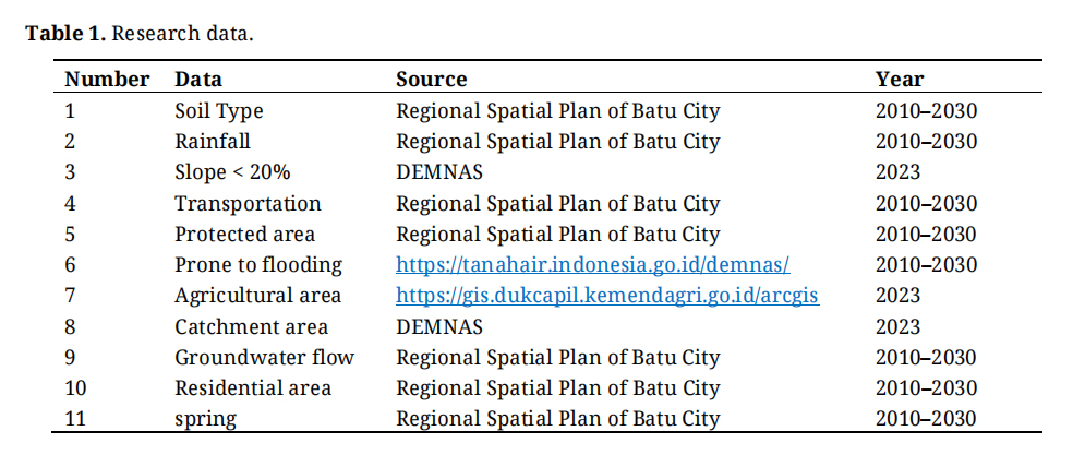 Table 1. Research data.
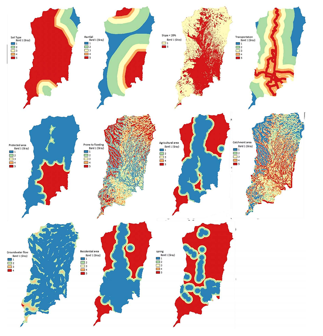 Figure 1. Proximity of driving factors analytical hierarchy process (AHP). Source: Analysis Results, 2023.
The analytical hierarchy process (AHP) is one of the Multi-Criteria Decision Analysis (MCDA) models, which is a decision support system considering multiple criteria, developed by Thomas L. Saaty in the 1970s [28]. Essentially, AHP is designed to rationally capture individual perceptions closely related to a specific issue by evaluating the system through a procedure designed to achieve a preference scale among various alternative sets [29]. AHP is used in weight assessment and measurement to determine a ratio scale through variable comparisons [30,31]. In this research, AHP is employed with the utilization of GIS tools to conduct the assessment. This process is carried out continuously until a suitable location is found as the landfill site. Before implementing the AHP analysis in GIS, a survey and the preparation of the Pairwise Comparison Matrix are conducted (Table 2). This matrix is used to compare and determine the relative weights between two elements in a scoring hierarchy. The matrix is obtained from distributing questionnaires to 8 expert respondents from local government, namely the Environmental Agency of Batu City and planning experts.
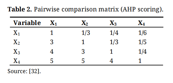 Table 2. Pairwise comparison matrix (AHP scoring).
The most well-known clustering method is K-means, developed by Mac Queen in 1967. The K-means method is highly popular due to its ability to quickly and efficiently cluster large datasets, including outlier data [33]. Clustering is an analytical model used to group data into different categories based on Partitioned Clustering [34–36]. K-means cluster is a fixed method that serves as the basic framework for developing numerical or conceptual clustering systems because of the various possibilities of paired distance selections between each instance in a dataset [37,38]. After obtaining suitable locations for the landfill site, the K-means clustering stage is carried out, dividing the data into five clusters. The K-means cluster analysis method in this research is used to determine priority clusters in selecting alternative landfill site locations.
The K-means clustering divides the alternative landfill site locations in Batu City based on the AHP priority scale and groups them into several clusters to assess which ones could potentially serve as new landfill sites in Batu City. The steps in this study began with making proximity to each data of driving factors and limiting factors. The results of proximity become input in AHP which will produce weights and feasible locations of landfill. The AHP results are processed using K-means clustering which produces alternative landfill priority locations.
Research FrameworkLandfill is an area specifically designated for the disposal of waste from Waste Collection Sites (TPS) and the community, with the goal of reducing waste piles in the community [39]. When selecting a landfill location, careful consideration is necessary to minimize negative impacts [40], and compliance with legal requirements and regulations is essential. Criteria for determining landfill locations include aspects stipulated in the standard [14]: (a) soils that do not have much variation in type are better; (b) small intensity rainfall is better; (c) slope <2 0%; (d) close to main road access; (e) not located in a protected area; (f) not in a flood-prone area; (g) not located on productive land such as agriculture; (h) catchment area or low rainfall area is considered better; (i) not close to groundwater flow; (j) distance or radius > 500 m from settlements; (k) not in the location of springs; and (k) away from airstrips of at least 3000 meters and turbo jet fields of 1500 meters.
In determining the alternative location for a landfill, a research framework (Figure 2) is implemented by considering two types of data, namely supporting factors and limiting factors. Supporting factors involve data such as soil type, rainfall, slope < 20%, transportation, flood susceptibility, catchment area, groundwater flow, and springs. Meanwhile, limiting factors include residential areas, protected areas, and agricultural areas. These data are then analyzed using the proximity method, which evaluates the distance between elements. Subsequently, weighting is applied to the pairwise comparison matrix, resulting in consistent ratios, weights for each data, and an alternative landfill map. After obtaining priority results, clustering is performed using the K-mean method to divide the prioritized alternative regions from AHP into 5 clusters, yielding the final priority alternatives for the landfill. The criteria used to determine the prioritized factors and locations involve all factors present in Batu City, and the evaluation is directly conducted by stakeholders from the Batu City Government’s Environmental Agency.
 Figure 2. Research framework. Source: Analysis Results, 2023.
One of the results of AHP is to give a relative weight to each criterion or factor used. Based on these weights, the best ranking of alternative landfill locations can be done. Figure 3 shows the consistent ratio value of 0.0224 from the factors used. This figure indicates that the comparisons made are consistent and not overly influenced by subjective preferences. In addition, it was also found that slope (0.125), groundwater flow system (0.117), flood prone condition (0.159), and settlement radius (0.138) were the most important factors in determining the landfill location.
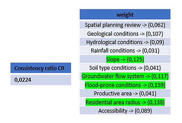 Figure 3. Results of AHP assessment. Source: Analysis Results, 2023.
In addition, the AHP in this study has also produced a Landfill Development Feasible Indication Map (Figure 4) by overlaying all landfill siting factors and including weight values. The feasible indication map is the feasible locations of landfill development based only on the driving factors, but has not accommodated the limiting factors of landfill development. Therefore, another overlay was conducted to overlay the Landfill Development Feasible Indication Map with the limiting factors to optimize the results based on the suitability of alternative landfill sites. The various locations of the limiting factors used in this study can be seen in Figure 5.
The results of the overlay stage between Figure 4 and Figure 5, as seen in Figure 6, provide information on locations that are suitable for landfill development. In Figure 6, there are a number of areas that have been selected as areas that meet the criteria to become landfills. The areas selected as feasible landfill sites include Giripurno, Pandanrejo, Bumiaji, Bulukerto, Sumbergondo, Sumber Brantas, Tulungrejo, Punten, Gunungsari, Songgokerto, Pesanggrahan, and Oro-oro Ombo Villages. The determination of these locations was based on a comprehensive evaluation of the factors affecting landfill development, including drivers and constraints.
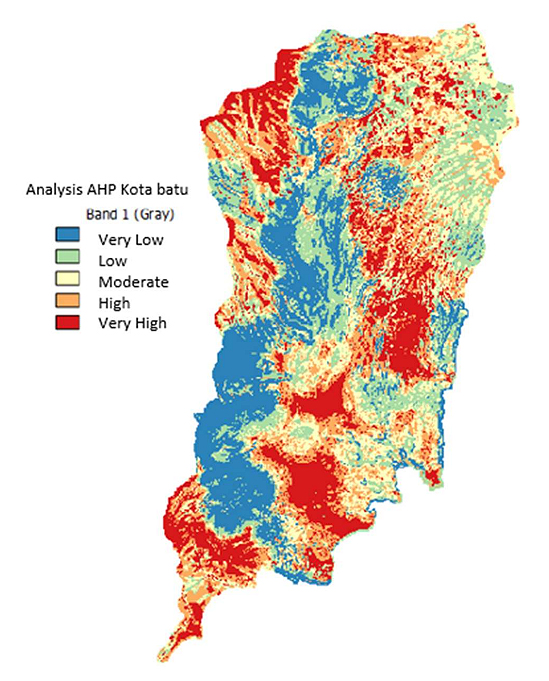 Figure 4. Landfill development feasible indication map. Source: Analysis Results, 2023.
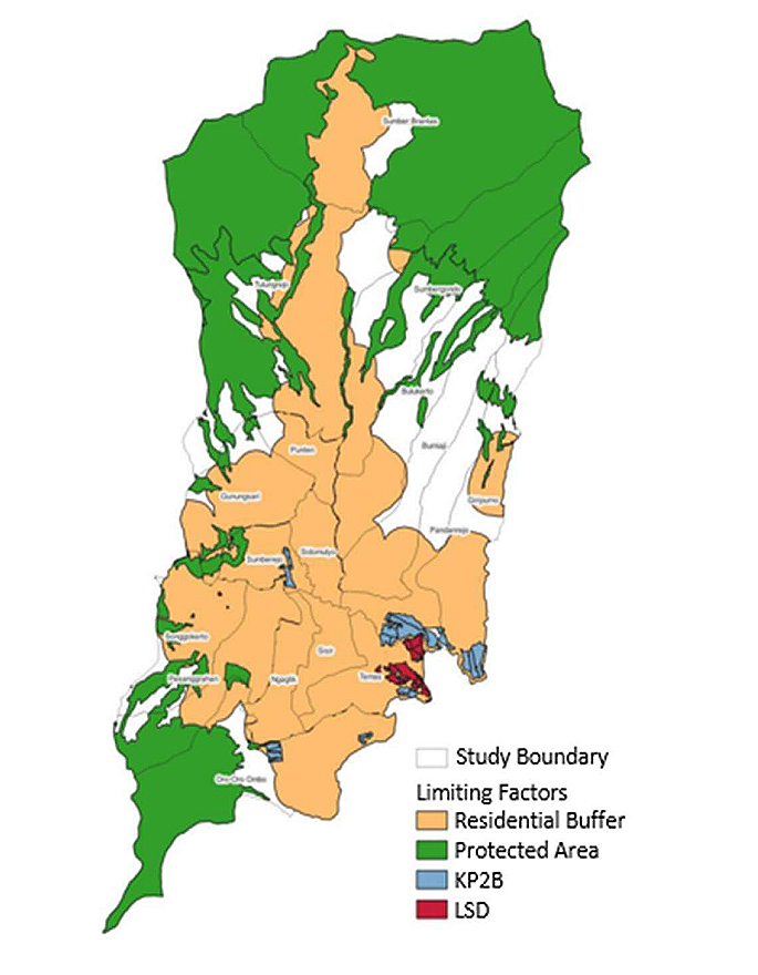 Figure 5. Map of limiting factors. Source: Analysis Results, 2023.
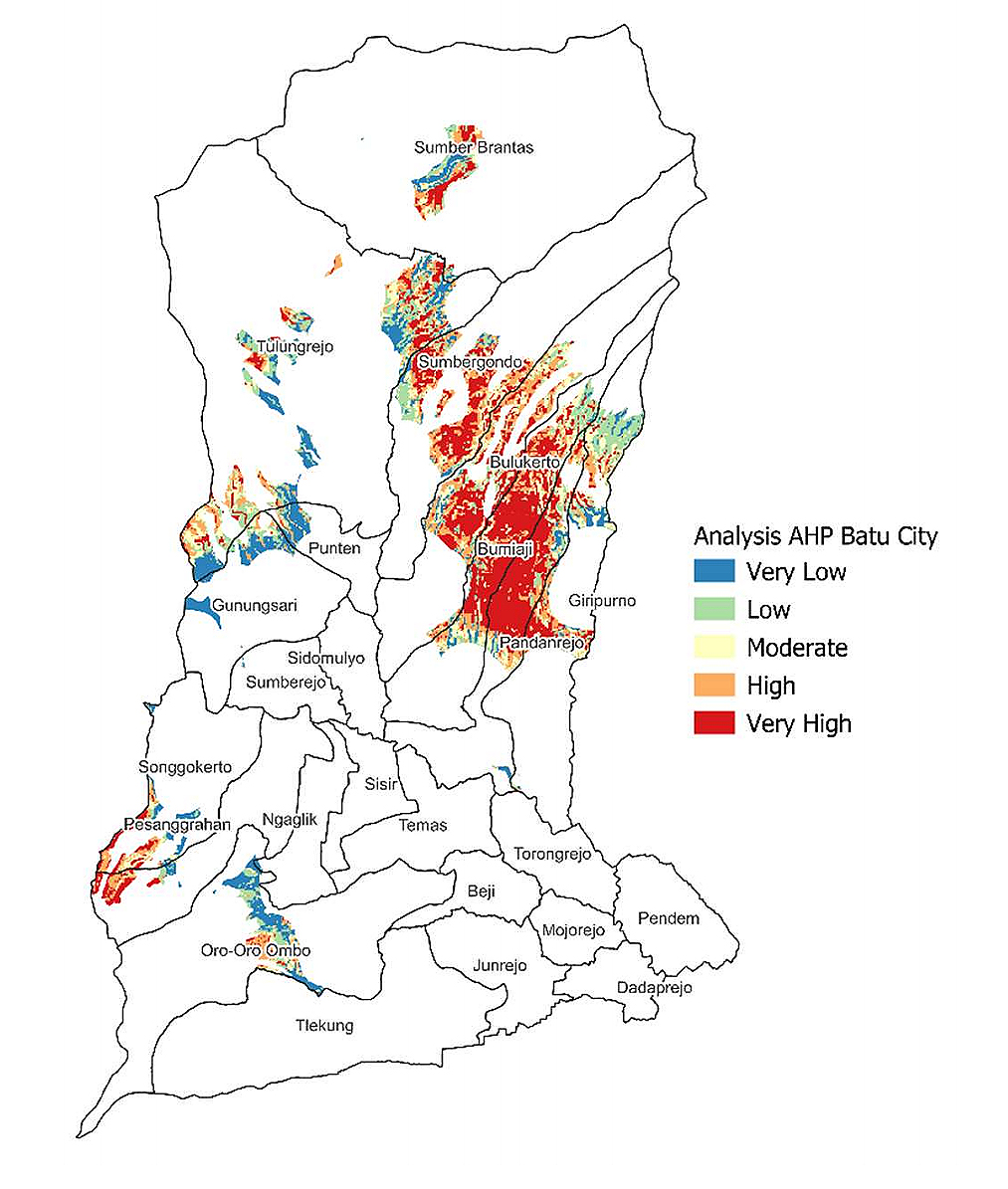 Figure 6. Map of landfill eligible sites. Source: Analysis Results, 2023.
K-means clustering analysis groups the AHP result values that have been tamped with limiting factors. This analysis resulted in 5 priority clusters of alternative landfill development alternatives for Batu City (Figure 7).
a.
b.
c.
d.
e.
The most prioritized cluster that can be used by the City Government as a location for landfill development in Batu City is in cluster 1. This cluster is a priority because it has a very high value of AHP analysis of its various factors. In contrast to other clusters, such as cluster 2 there are very high factor values, but also has some low factor values. Then, clusters 3–5 are also not prioritized because the AHP values of various factors are dominated by very low numbers.
 Figure 7. Landfill development alternative priority cluster map. Source: Analysis Results, 2023.
The selection of landfill site location factors is supported by clay-textured soil types, which are more suitable due to their moderate soil permeability rate [41–43]. Slope inclination should be less than 20% as locations with less steep slopes are required for easier construction. Lower rainfall is preferable as continuous rainfall on the landfill site may lead to increased leachate. Landfill site locations should also be distant from groundwater flow areas, springs, and flood-prone areas to prevent contamination of surrounding water bodies [41,43,44]. Limiting factors for landfill site locations include proximity to residential areas, as odors from the waste may disrupt daily life, and exclusion from protected areas and agricultural zones to avoid disturbance or damage to protected forests and crop production [41,43].
In other studies [44,45] examining alternative landfill locations using the theoretical framework of legislation and Simple Addictive Weighting, the use of this method is less precise as it relies solely on theory without considering suitable locations. In comparison to the Batu landfill study using the AHP method, its advantage lies in directly determining priority scales in suitable areas. In the study conducted by [40], the parameters used to develop the landfill were (a) rainfall, (b) drainage density, (c) line density, (d) health care facilities, (e) airport, (f) slope, (g) proximity to surface water, (h) educational institutions, (i) road network, (j) vegetation density, (k) elevation, and (l) land use/land cover. [46] categorizes landfill suitability factors into three groups, which include morphological, environmental, and socioeconomic factors. In accordance with [47]’s study, infrastructure projects represent an amalgamation of urban transformation, community development, culture and technology through sustainable design. Urban rejuvenation and renewal show that infrastructure projects have the potential to be smart and ecologically sound as well as culturally integrated urban interventions. Education, increased publicity and availability of facilities are also very important to support improved waste management [48]. As sustainable municipal waste management planning must address several interrelated issues such as landfill capacity, environmental impacts and financial expenditure, it becomes increasingly important to understand the dynamic nature of their interactions [49]. Socio-economic aspects should be adequately included in developing landfill closure plans to reduce the negative impacts of such closures on local communities [50]. The new alternative landfill site locations are more suitable because they are located far from residential areas and agricultural land to avoid disrupting the activities of the surrounding community. Furthermore, to prevent future issues of insufficient landfill space in Batu City, it is hoped that the government will also consider developing waste management concepts such as sanitary landfills.
This research successfully achieved its goal of determining alternative locations for landfill development in Batu City using AHP analysis and K-means clustering. Through AHP analysis, the highest weights of four variables were obtained, namely flood-prone areas, settlement radius, slope < 20%, and groundwater flow. The feasible locations for landfill development are located in Giripurno, Pandanrejo, Bumiaji, Bulukerto, Sumbergondo, Sumber Brantas, Tulungrejo, Punten, Gunungsari, Songgokerto, Pesanggrahan, and Oro-oro Ombo villages. In addition, the K-means clustering analysis resulted in five priority clusters that can be alternative locations for future landfill development. Cluster 1 was identified as a priority cluster that includes Bumiaji, Pandanrejo, Giripurno, and Bulukerto villages.
The results of this research are expected to provide valuable input for the Batu City Government in overcoming landfill problems. However, there are shortcomings in this research, namely the lack of available data on land ownership that can facilitate the land acquisition process by the government and the lack of involvement from the surrounding community of Batu City in the assessment process is also a concern. This research is unique because it integrates AHP and GIS methods. On the other hand, this approach has the weakness of only evaluating priorities based on numerical values without considering priority locations. In contrast, the approach in this research updates the approach by combining AHP and GIS methods. For future research, it is recommended to collect more information about land ownership and involve relevant stakeholders in the decision-making process regarding the location of landfill development. Thus, it can be expected that the results of this research can better support the implementation and sustainability of landfill development in Batu City.
All data generated from the study are available in the manuscript file.
LS developed the idea and plan for this project, supervised the entire research, and reviewed and edited the manuscript. FDD and FA developed the idea and plan for this project, collected the data, and performed the analysis. ADH, NP, NA conducted a literature review and edited the manuscript.
The authors declare that there is no conflict of interest.
The authors would like to express gratitude to PT. Sagamartha Ultitma and Universitas Terbuka, which has provided a fee for this research.
The authors would like to express greatly appreciate to the editor’s constructive comments on the earlier drafts of the manuscript. The authors also show appreciation to the anonymous reviewers for their insightful and constructive comments, driving a significant improvement of the manuscript.
1.
2.
3.
4.
5.
6.
7.
8.
9.
10.
11.
12.
13.
14.
15.
16.
17.
18.
19.
20.
21.
22.
23.
24.
25.
26.
27.
28.
29.
30.
31.
32.
33.
34.
35.
36.
37.
38.
39.
40.
41.
42.
43.
44.
45.
46.
47.
48.
49.
50.
Sulistyowati L, Dzulfiqar FD, Hariyanto AD, Pusporini N, Afrianto F, Andareswari N. Integrating Multi-Criteria Evaluation Techniques with Geographic Information Systems for Landfill Site Selection: A Case Study in Batu City Indonesia. J Sustain Res. 2024;6(2):e240017. https://doi.org/10.20900/jsr20240017

Copyright © 2023 Hapres Co., Ltd. Privacy Policy | Terms and Conditions


